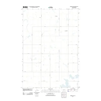
2012 Map of Bowdle SW
USGS Topo · Published 2012About this map
Alkali Lake dominates the southeast corner of this section of Edmunds County, a significant water body in an otherwise high-prairie landscape defined by section-line roads and dispersed farmsteads. The terrain is part of a complex hydrologic network where Swan Lake Cr meanders across the northwest, providing a natural contrast to the rigid grid of rural routes such as 140th St and 323rd Ave. Religious and family heritage is anchored by two distinct sites of local importance: the Congregational Cem in the north and the Seventh-Day Adventist Cem further south. These markers provide essential points of reference for genealogists tracking early settlement patterns in this part of South Dakota, where the economy remains tied to the vast, open spaces between these historic cemeteries.
Find a feature on this map
19 named features on this map. Tap any name to fly to it.
Don’t see what you’re looking for? This feature index may not catch every label — zoom into the map to look around manually.
Map Details
Editions of this 2012 Bowdle SW Map
This is the sole edition of this map. No revisions or reprints were ever made.
Other maps of this area

1954 · Aberdeen
USGS Topo · 1:250,000

1956 · Aberdeen
USGS Topo · 1:250,000

1974 · Gretna
USGS Topo · 1:24,000

1974 · Hoven
USGS Topo · 1:24,000

1974 · Hoven Muni. Airport
USGS Topo · 1:24,000

1974 · Spring Lake
USGS Topo · 1:24,000

1974 · Bowdle SE
USGS Topo · 1:24,000

1974 · Bowdle
USGS Topo · 1:24,000
1978 · Tolstoy
USGS Topo · 1:24,000

1978 · Seneca NW
USGS Topo · 1:24,000