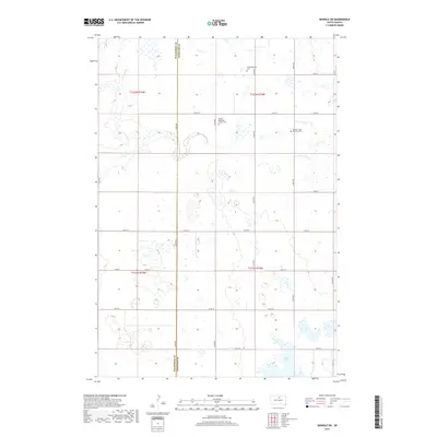
2017 Map of Bowdle SW
USGS Topo · Published 2017About this map
United Methodist Church Cem and the Seventh - Day Adventist Cem sit within a landscape defined by the prairie potholes and seasonal wetlands of the Missouri Coteau. This 2017 survey by the U.S. Geological Survey documents the rural expanse of southern Edmunds County, where the terrain is marked by the winding course of Swan Lake Cr and the presence of Alkali Lake in the southeast corner. The map illustrates a strictly organized grid of section lines and secondary routes like Co Rd 10 and Co Rd 1A, which connect remote farmsteads and historical burial sites such as the Congregational Cem. Straddling the border with Walworth County, this area represents a classic South Dakota agricultural interior, largely unchanged in its spatial layout since the early days of township settlement.
Find a feature on this map
24 named features on this map. Tap any name to fly to it.
Don’t see what you’re looking for? This feature index may not catch every label — zoom into the map to look around manually.
Map Details
Editions of this 2017 Bowdle SW Map
This is the sole edition of this map. No revisions or reprints were ever made.
Other maps of this area
1954 · Aberdeen
USGS Topo · 1:250,000
1956 · Aberdeen
USGS Topo · 1:250,000
1974 · Gretna
USGS Topo · 1:24,000
1974 · Hoven
USGS Topo · 1:24,000
1974 · Hoven Muni. Airport
USGS Topo · 1:24,000
1974 · Spring Lake
USGS Topo · 1:24,000
1974 · Bowdle SE
USGS Topo · 1:24,000
1974 · Bowdle
USGS Topo · 1:24,000
1978 · Tolstoy
USGS Topo · 1:24,000
1978 · Seneca NW
USGS Topo · 1:24,000