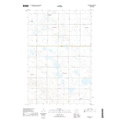
2020 Map of Bowdon SE
USGS Topo · Published 2020About this map
Glacial potholes and prairie wetlands dominate this landscape along the border of Wells and Kidder counties. The area is defined by a dense network of sectional roads and a scatter of rural landmarks that speak to the region's spiritual and logistical history. The Bowdon Country Seventh Day Adventist Cem and a second Seventh Day Adventist Cem further south serve as significant markers for family historians tracing early settlement patterns in this part of North Dakota. In the northwest corner, the Buchmiller Airport provides a modern navigational waypoint amidst the undulating terrain. A systematic grid of thoroughfares, including Co Rd 70 and 44th Ave SE, connects the disparate farmsteads and natural basins that characterize this rural expanse.
Find a feature on this map
26 named features on this map. Tap any name to fly to it.
Don’t see what you’re looking for? This feature index may not catch every label — zoom into the map to look around manually.
Map Details
Editions of this 2020 Bowdon SE Map
This is the sole edition of this map. No revisions or reprints were ever made.
Other maps of this area

1951 · Bowdon
USGS Topo · 1:24,000

1951 · Heaton
USGS Topo · 1:24,000

1951 · Sykeston
USGS Topo · 1:24,000

1952 · New Rockford
USGS Topo · 1:250,000

1956 · New Rockford
USGS Topo · 1:250,000

1971 · New Rockford
USGS Topo · 1:250,000

1972 · Lake Williams
USGS Topo · 1:24,000
1972 · Woodworth NW
USGS Topo · 1:24,000

1972 · Des Moines Lake
USGS Topo · 1:24,000

1978 · Wagon Wheel Hill
USGS Topo · 1:24,000