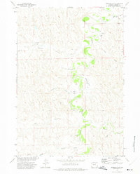
1972 Map of Bowman Flat
USGS Topo · Published 1975About this map
The Powder River carves a meandering course through this Johnson County landscape, defining the character of the terrain during the early 1970s. The river's path is flanked by wide, level expanses such as Bowman Flat and Culp Flat, which contrast with the intricate network of drainage channels that feed the basin. This survey illustrates a rural economy reliant on water and transport, featuring multiple landing areas including a Landing Strip and a designated Landing Field positioned near the river's bends. A complex system of ephemeral draws, including Hupp Draw, Red Draw, and Hynes Draw, illustrates the region's hydraulic patterns. The presence of a major Pipeline cutting across the southern sections near Pumpkin Creek points to the infrastructure development supporting the Missouri River Basin project during this era.
Find a feature on this map
15 named features on this map. Tap any name to fly to it.
Don’t see what you’re looking for? This feature index may not catch every label — zoom into the map to look around manually.
Map Details
Editions of this 1972 Bowman Flat Map
This is the sole edition of this map. No revisions or reprints were ever made.
Other maps of this area

1953 · Hoe Ranch
USGS Topo · 1:24,000

1953 · The Nipple
USGS Topo · 1:24,000

1955 · Sheridan
USGS Topo · 1:250,000

1955 · Arminto
USGS Topo · 1:250,000

1958 · Sheridan
USGS Topo · 1:250,000

1958 · Arminto
USGS Topo · 1:250,000

1961 · Provence Ranch
USGS Topo · 1:24,000

1962 · Sheridan
USGS Topo · 1:250,000

1962 · Arminto
USGS Topo · 1:250,000
1972 · Ploessers Draw
USGS Topo · 1:24,000