
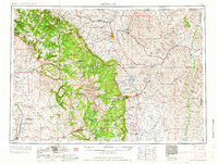
1958 Map of Sheridan
USGS Topo · Published 1958About this map
The Bighorn Mountains dominate the western landscape of this mid-century survey, rising sharply from the basin floor to the high granite summits of Cloud Peak and Blacktooth Mountain. This transition from the arid plains to the alpine terrain of the Bighorn National Forest defines the regional economy, where the Tongue River and Powder River support sprawling livestock operations like the Eaton Bros Ranch and Beckton Stock Farm. Significant industrial activity is evident in the coal fields near Sheridan, including the Kleenburn Coal Tipple and Custer Coal Mine, while the southern reaches of the map show the extraction infrastructure of the Hidden Dome Oil & Gas Field and the Big Horn Sulphur Plant. Historical markers like the Massacre Hill Monument and the Father De Smet Monument reflect the area's complex frontier history, while the Fort Mackenzie Veteran Hospital and Wyoming Soldiers and Sailors Home indicate the established civic presence in the postwar era.
Find a feature on this map
100 named features on this map. Tap any name to fly to it.
Don’t see what you’re looking for? This feature index may not catch every label — zoom into the map to look around manually.
Map Details
Editions of this 1958 Sheridan Map
2 editions found
Other maps of this area

1894 · Rosebud
USGS Topo · 1:125,000

1894 · St. Xavier
USGS Topo · 1:125,000

1895 · Dayton
USGS Topo · 1:125,000

1898 · Bald Mountain
USGS Topo · 1:125,000

1899 · Cloud peak
USGS Topo · 1:125,000

1900 · Fort McKinney
USGS Topo · 1:125,000

1901 · Rosebud
USGS Topo · 1:125,000

1901 · Cloud Peak
USGS Topo · 1:125,000

1901 · Dayton
USGS Topo · 1:125,000

1901 · St. Xavier
USGS Topo · 1:125,000