
Loading...
Loading map...1895 Map of Dayton
USGS Topo · Published 1895About this map
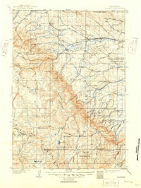
The Bighorn Mountains dominate the western half of this 1891 survey, rising sharply from the plains as a high-altitude barrier along the eastern edge of Bighorn Co. and Sheridan Co. This terrain is deeply incised by drainages like Wolf Creek and Big Goose Creek, which flow eastward toward the early settlement hubs of the foothills. At this time, the Tongue River valley serves as the primary corridor for human activity, connecting the small communities of Dayton and Bingham.
Find a feature on this map
25 named features on this map. Tap any name to fly to it.
Don’t see what you’re looking for? This feature index may not catch every label — zoom into the map to look around manually.
Map Details
Date Portrayed1895
Date Published1895
PublisherU.S. Geological Survey
Map TypeTopographic
Scale1:125,000
Physical Dimensions16.1 x 20.3 inches
Editions of this 1895 Dayton Map
This is the sole edition of this map. No revisions or reprints were ever made.
Historical Maps of Sheridan Through Time
Featured Locations
Source Details
SourceU.S. Geological Survey
CopyrightPublic Domain