1894 Map of St. Xavier
USGS Topo · Published 1894About this map
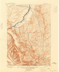
St. Xavier Mission stands as a central landmark in this 1890s landscape within the Crow Indian Reservation. The geography is defined by the convergence of major waterways, including the Big Horn River and the Little Big Horn River, which carve through the northern reaches of the Big Horn Mountains. An interpretive highlight for researchers is the marking of the Old Bozeman Military Road, a critical transit artery of the late 19th century that winds through the drainage basins of Rotten Grass Creek and Lodge Grass Creek. The presence of the Site of Old Fort C. F. Smith near Lime Kiln Creek provides a direct link to the region's military history. This survey by Frank Tweedy and A. H. Thompson captures the territory just north of the Montana Wyoming Boundary Line during a period of transition for the Crow Nation and the western frontier.
Find a feature on this map
16 named features on this map. Tap any name to fly to it.
Don’t see what you’re looking for? This feature index may not catch every label — zoom into the map to look around manually.
Map Details
Editions of this 1894 St. Xavier Map
This is the sole edition of this map. No revisions or reprints were ever made.