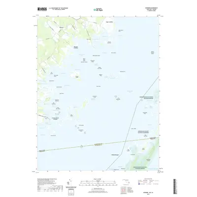
2019 Map of Boxiron
USGS Topo · Published 2019About this map
The Maryland-Virginia state line bisects Chincoteague Bay in this coastal survey, where the marshy transition between land and water defines the local geography. Small water-access points like George Island Landing, Boxiron Landing, and Figgs Landing connect the inland roads to a complex network of thoroughfares and guts. The landscape is a mosaic of named marshes and hummocks, such as Pikes Creek Marsh and Purnell Hummock, reflecting centuries of maritime adaptation. Significant conservation areas including Chincoteague National Wildlife Refuge and Assateague Island National Seashore protect the outer banks and barrier islands. Inland, the settlement of Boxiron sits at a crossroads of rural routes like Boxiron Rd and Cherrix Rd, serving as a gateway to the intricate tidal estuaries and islands like Mills Island and Assacorkin Island.
Find a feature on this map
95 named features on this map. Tap any name to fly to it.
Don’t see what you’re looking for? This feature index may not catch every label — zoom into the map to look around manually.
Map Details
Editions of this 2019 Boxiron Map
This is the sole edition of this map. No revisions or reprints were ever made.
Other maps of this area

1901 · Snow Hill
USGS Topo · 1:62,500

1901 · Green Run
USGS Topo · 1:62,500

1938 · Green Run
USGS Topo · 1:62,500

1942 · Chincoteague East
USGS Topo · 1:24,000

1942 · Snow Hill
USGS Topo · 1:24,000

1942 · Tingles Island
USGS Topo · 1:24,000

1942 · Wesley
USGS Topo · 1:24,000

1943 · Snow Hill
USGS Topo · 1:31,680

1943 · Boxiron
USGS Topo · 1:31,680

1943 · Whittington Point
USGS Topo · 1:31,680