
1932 Map of Boyce SW
USGS Topo · Published 1932About this map
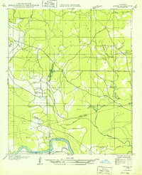
Hotwell and the surrounding Rapides Parish landscape appear here as a complex network of bayous, small lakes, and early rural settlements in the early 1930s. The northern portion is defined by the Bayou Cocatriz and several small water bodies including Jackson Lake and Cotile Lake, which drained toward the agricultural lowlands. Evidence of the region's timber and transit history is visible through the Lumber R.R. in the northwest and an Old Railroad Grade further south, illustrating the shift in industrial infrastructure.
Find a feature on this map
52 named features on this map. Tap any name to fly to it.
Don’t see what you’re looking for? This feature index may not catch every label — zoom into the map to look around manually.
Map Details
Editions of this 1932 Boyce SW Map
This is the sole edition of this map. No revisions or reprints were ever made.
Other maps of this area
1932 · Boyce NE
USGS Topo · 1:31,680

1937 · Chopin NE
USGS Topo · 1:31,680

1937 · Chopin SE
USGS Topo · 1:31,680
1941 · Boyce
USGS Topo · 1:62,500
1943 · Leander
USGS Topo · 1:62,500

1944 · Chopin
USGS Topo · 1:62,500

1945 · Boyce SE
USGS Topo · 1:31,680

1948 · Chopin
USGS Topo · 1:62,500

1949 · Boyce NW
USGS Topo · 1:31,680

1949 · Boyce SE
USGS Topo · 1:31,680