
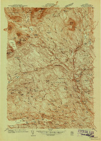
1951 Map of Boyd Lake
USGS Topo · Published 1951About this map
The Piscataquis River and Pleasant River converge in the northern reaches of this mid-century survey, a landscape defined by its timber-heavy terrain and significant peat bogs. The Bangor and Aroostook railroad serves as the primary industrial spine, running through South Lagrange and past Ricker Siding. Local community life is anchored by a network of rural schoolhouses, including Hoxie Sch, Williams Sch, and the Bradford High Sch.
Find a feature on this map
67 named features on this map. Tap any name to fly to it.
Don’t see what you’re looking for? This feature index may not catch every label — zoom into the map to look around manually.
Map Details
Editions of this 1951 Boyd Lake Map
This is the sole edition of this map. No revisions or reprints were ever made.
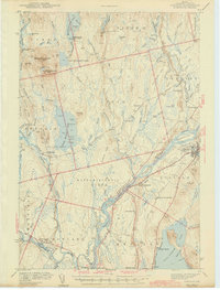
Other maps of this area

1902 · Orono
USGS Topo · 1:62,500

1902 · Bangor
USGS Topo · 1:62,500

1917 · Passadumkeag
USGS Topo · 1:62,500

1931 · Stetson
USGS Topo · 1:48,000

1932 · Dover-Foxcroft
USGS Topo · 1:48,000

1933 · Boyd Lake
USGS Topo · 1:62,500

1935 · Dover-Foxcroft
USGS Topo · 1:62,500

1935 · Stetson
USGS Topo · 1:62,500
1940 · Sebec
USGS Topo · 1:48,000
1942 · Lincoln
USGS Topo · 1:62,500