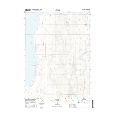
2015 Map of Boyd Spring
USGS Topo · Published 2015About this map
Upper Lake defines the western margin of this Modoc County landscape, where the high desert terrain transitions into a complex network of seasonal water management and natural drainages. The area is characterized by several catchment features, including Level Reservoir, Hawk Reservoir, and Boggs Reservoir, which suggest a land use centered on livestock or water conservation in a semi-arid environment. Further inland, the eponymous Boyd Spring serves as a critical water source tucked into the hills. The terrain is deeply inscribed by several watercourses such as First Cr, Second Cr, and Sand Cr, which cut through the landscape toward the Lieberman Canyon area. This 2015 survey illustrates a sparsely populated region primarily accessed by established county routes like Co Road 15A and Co Road 7.
Find a feature on this map
20 named features on this map. Tap any name to fly to it.
Don’t see what you’re looking for? This feature index may not catch every label — zoom into the map to look around manually.
Map Details
Editions of this 2015 Boyd Spring Map
This is the sole edition of this map. No revisions or reprints were ever made.
Other maps of this area
1886 · Alturas
USGS Topo · 1:250,000
1889 · Long Valley
USGS Topo · 1:250,000
1892 · Alturas
USGS Topo · 1:250,000

1954 · Vya
USGS Topo · 1:250,000
1954 · Alturas
USGS Topo · 1:250,000
1958 · Alturas
USGS Topo · 1:250,000

1958 · Vya
USGS Topo · 1:250,000
1962 · Alturas
USGS Topo · 1:250,000

1962 · Vya
USGS Topo · 1:250,000
1962 · Cedarville
USGS Topo · 1:62,500