
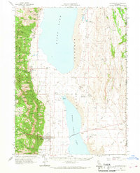
1962 Map of Cedarville
USGS Topo · Published 1964About this map
Cedarville and Lake City anchor the western edge of the Surprise Valley, situated at the base of the Warner Mountains within the Modoc National Forest. This 1962 survey reveals a landscape defined by the drainage of numerous canyons, including Lake City Canyon Creek and Cedar Creek, which flow toward the expansive beds of Upper Surprise Lake and Middle Alkali Lake. The presence of Leonards Hot Springs, a Steam Well, and a Radio Facility suggests a region balancing geothermal activity with mid-century infrastructure. A prominent Causeway bisects the alkaline lake beds, linking the main settlements to The Fortynine Road and the Nevada border. Local history is preserved through labels for the Cedarville Cem, the Surprise Valley Union High Sch, and the County Fairgrounds, alongside several family-named outposts like Boyd Spring Ranch and Parman Ranch.
Find a feature on this map
61 named features on this map. Tap any name to fly to it.
Don’t see what you’re looking for? This feature index may not catch every label — zoom into the map to look around manually.
Map Details
Editions of this 1962 Cedarville Map
2 editions found
Other maps of this area

1886 · Alturas
USGS Topo · 1:250,000

1889 · Long Valley
USGS Topo · 1:250,000

1892 · Alturas
USGS Topo · 1:250,000

1954 · Vya
USGS Topo · 1:250,000

1954 · Alturas
USGS Topo · 1:250,000

1958 · Alturas
USGS Topo · 1:250,000

1958 · Vya
USGS Topo · 1:250,000

1962 · Alturas
USGS Topo · 1:250,000

1962 · Vya
USGS Topo · 1:250,000

1962 · Davis Creek
USGS Topo · 1:62,500