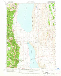
1962 Map of Cedarville
USGS Topo · Published 1968About this map
Cedarville Rancheria and the town of Cedarville stand at the intersection of high desert and alpine forest in the early 1960s. The landscape is defined by the stark contrast between the Warner Mountains, sheltered within the Modoc National Forest, and the expansive Surprise Valley floor. Water is the primary driver of settlement here, with numerous perennial streams like Soldier Creek and Cedar Creek flowing from the peaks toward Upper Lake and Middle Alkali Lake.
Find a feature on this map
55 named features on this map. Tap any name to fly to it.
Don’t see what you’re looking for? This feature index may not catch every label — zoom into the map to look around manually.
Map Details
Editions of this 1962 Cedarville Map
2 editions found

Other maps of this area

1886 · Alturas
USGS Topo · 1:250,000

1889 · Long Valley
USGS Topo · 1:250,000

1892 · Alturas
USGS Topo · 1:250,000

1954 · Vya
USGS Topo · 1:250,000

1954 · Alturas
USGS Topo · 1:250,000

1958 · Alturas
USGS Topo · 1:250,000

1958 · Vya
USGS Topo · 1:250,000

1962 · Alturas
USGS Topo · 1:250,000

1962 · Vya
USGS Topo · 1:250,000

1962 · Davis Creek
USGS Topo · 1:62,500