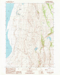
1990 Map of Boyd Spring
USGS Topo · Published 1990About this map
Surprise Valley dominates this high-desert landscape in northeastern California, where the expansive Upper Surprise Lake meets the eastern slopes of the Warner Mountains. The map documents a sparsely populated ranching environment centered around the Boyd Spring Ranch and its namesake Boyd Spring. A complex system of water management is visible through numerous named catchments, including Level Reservoir, Hawk Reservoir, and Boggs Reservoir, which support the arid grazing lands between Lieberman Canyon and the valley floor.
Find a feature on this map
18 named features on this map. Tap any name to fly to it.
Don’t see what you’re looking for? This feature index may not catch every label — zoom into the map to look around manually.
Map Details
Editions of this 1990 Boyd Spring Map
This is the sole edition of this map. No revisions or reprints were ever made.
Other maps of this area

1886 · Alturas
USGS Topo · 1:250,000

1889 · Long Valley
USGS Topo · 1:250,000

1892 · Alturas
USGS Topo · 1:250,000

1954 · Vya
USGS Topo · 1:250,000

1954 · Alturas
USGS Topo · 1:250,000

1958 · Alturas
USGS Topo · 1:250,000

1958 · Vya
USGS Topo · 1:250,000

1962 · Alturas
USGS Topo · 1:250,000

1962 · Vya
USGS Topo · 1:250,000

1962 · Cedarville
USGS Topo · 1:62,500