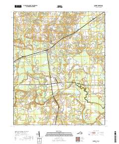
2019 Map of Boykins
USGS Topo · Published 2019About this map
The Meherrin River meanders across the border of Virginia and North Carolina, defining the landscape of the coastal plain between Southampton, Northampton, and Hertford Counties. The town of Boykins serves as a central hub, where Virginia Ave and Main St intersect amidst a network of rural roads such as Old Branchville Rd and Cross Keys Rd. The area is characterized by significant wetlands, including Buckhorn Swamp and Burnt Reed Swamp, which illustrate the low-lying nature of the Tidewater region.
Find a feature on this map
62 named features on this map. Tap any name to fly to it.
Don’t see what you’re looking for? This feature index may not catch every label — zoom into the map to look around manually.
Map Details
Editions of this 2019 Boykins Map
This is the sole edition of this map. No revisions or reprints were ever made.
Other maps of this area

1919 · Boykins
USGS Topo · 1:48,000

1919 · Arringdale
USGS Topo · 1:48,000

1920 · Boykins
USGS Topo · 1:62,500

1920 · Arringdale
USGS Topo · 1:62,500

1942 · Arringdale
USGS Topo · 1:62,500

1953 · Norfolk
USGS Topo · 1:250,000
1966 · Capron
USGS Topo · 1:24,000
1966 · Drewryville
USGS Topo · 1:24,000

1966 · Margarettsville
USGS Topo · 1:24,000

1966 · Sunbeam
USGS Topo · 1:24,000