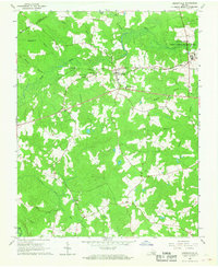
1966 Map of Drewryville
USGS Topo · Published 1968About this map
Drewryville sits at the heart of this mid-1960s Southampton County landscape, where the Norfolk and Western railway bisects a terrain defined by extensive swamp networks. The map documents a rural community centered on its spiritual and educational hubs, including the Drewryville District Sch and Thomas Memorial Ch. To the northwest, the settlement of Arringdale marks the rail line near the Sussex Co Southampton Co boundary, while the northeastern corner is dominated by the Southampton State Correctional Farm.
Find a feature on this map
32 named features on this map. Tap any name to fly to it.
Don’t see what you’re looking for? This feature index may not catch every label — zoom into the map to look around manually.
Map Details
Editions of this 1966 Drewryville Map
2 editions found
Other maps of this area

1919 · Jarratt
USGS Topo · 1:62,500

1919 · Homeville
USGS Topo · 1:48,000

1919 · Boykins
USGS Topo · 1:48,000

1919 · Arringdale
USGS Topo · 1:48,000

1920 · Homeville
USGS Topo · 1:62,500

1920 · Boykins
USGS Topo · 1:62,500

1920 · Arringdale
USGS Topo · 1:62,500

1942 · Arringdale
USGS Topo · 1:62,500

1943 · Sebrell
USGS Topo · 1:31,680

1951 · Jarratt
USGS Topo · 1:62,500