
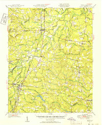
1951 Map of Jarratt
USGS Topo · Published 1952About this map
The Nottoway River meanders through the heart of Sussex and Greensville counties, defining a landscape of dense swamps and dispersed rural communities. This mid-century survey reveals a settlement pattern tied closely to both the waterways and the Atlantic Coast Line and Virginian railroads, which intersect at the town of Jarratt. The presence of Fort Nottoway near the river suggests a layer of earlier history, while the numerous small churches and schools like Little Bethel Ch, Jerusalem Ch, and Halifax Sch indicate a deeply rooted social structure. Economic activity is anchored by several local operations including Winfields Mill and Howells Mill, situated along the various creek and swamp drainages. Notable infrastructure like the Blue Star Memorial Highway and Green Church Bridge highlights the evolving transportation network that moved goods and people across the sprawling swamp systems of Sappony Creek and Poplar Swamp.
Find a feature on this map
90 named features on this map. Tap any name to fly to it.
Don’t see what you’re looking for? This feature index may not catch every label — zoom into the map to look around manually.
Map Details
Editions of this 1951 Jarratt Map
2 editions found
Other maps of this area

1894 · Petersburg
USGS Topo · 1:62,500

1897 · Amelia
USGS Topo · 1:125,000

1919 · Jarratt
USGS Topo · 1:62,500

1919 · Mc Kenney
USGS Topo · 1:48,000

1919 · Disputanta
USGS Topo · 1:62,500

1919 · Homeville
USGS Topo · 1:48,000

1919 · Boykins
USGS Topo · 1:48,000

1919 · Emporia
USGS Topo · 1:62,500

1919 · Arringdale
USGS Topo · 1:48,000

1920 · Homeville
USGS Topo · 1:62,500