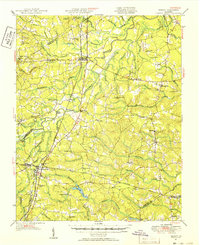
1951 Map of Jarratt
USGS Topo · Published 1952About this map
Stony Creek and the southern Virginia lowlands are defined by an intricate network of wetlands and river crossings in this mid-century topographic record. The Nottoway River meanders through the center of the sheet, surrounded by extensive swamp systems like Cabin Point Swamp and Hunting Quarter Swamp. Transportation corridors are critical to the region's layout, with the Atlantic Coast Line and Virginian railroads intersecting at Jarratt. The presence of several family and community landmarks, such as Winfields Mill, Howells Mill, and the Peagram Cem, indicates a deeply rooted rural society.
Find a feature on this map
90 named features on this map. Tap any name to fly to it.
Don’t see what you’re looking for? This feature index may not catch every label — zoom into the map to look around manually.
Map Details
Editions of this 1951 Jarratt Map
2 editions found

Other maps of this area

1894 · Petersburg
USGS Topo · 1:62,500

1897 · Amelia
USGS Topo · 1:125,000

1919 · Jarratt
USGS Topo · 1:62,500

1919 · Mc Kenney
USGS Topo · 1:48,000

1919 · Disputanta
USGS Topo · 1:62,500

1919 · Homeville
USGS Topo · 1:48,000

1919 · Boykins
USGS Topo · 1:48,000

1919 · Emporia
USGS Topo · 1:62,500

1919 · Arringdale
USGS Topo · 1:48,000

1920 · Homeville
USGS Topo · 1:62,500