1919 Map of Disputanta
USGS Topo · Published 1919About this map
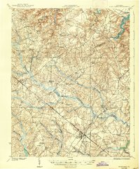
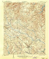
The Norfolk and Western railroad anchors the commercial landscape of this 1919 survey, cutting a straight path through the heart of the coastal plain south of the James River. This artery connects the primary hubs of Waverly and Disputanta, which serve as the commercial focus for a countryside of dispersed agrarian settlements and small crossroads. To the north, the terrain is defined by tidal inlets like Wards Creek and Cabin Point Creek, while the central and southern portions are dominated by an intricate network of wetlands, including the expansive Blackwater Swamp and Otterdam Swamp.
Find a feature on this map
49 named features on this map. Tap any name to fly to it.
Don’t see what you’re looking for? This feature index may not catch every label — zoom into the map to look around manually.
Map Details
Editions of this 1919 Disputanta Map
3 editions found