
1918 Map of Toano
USGS Topo · Published 1918About this map
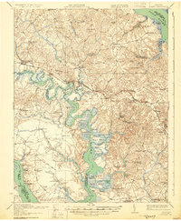
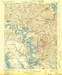
The Chickahominy River snakes through the heart of the Virginia Peninsula in this 1917 survey, revealing a landscape defined by intricate tidal necks and islands. The Chesapeake and Ohio railroad corridor anchors the inland settlements of Toano, Norge, and Lanexa, while the surrounding countryside is dotted with community centers such as Hickory Neck Church and St John Church. The map provides an incredible view of early 20th-century transportation, showing river crossings like Barrets Ferry and several landings including Cypress Bank Landing and Shipyard Landing. To the north, the York River forms a wide boundary near Terrapin Point, while the southern reaches meet the James River at Trees Pt Wharf. Numerous rural schools, such as One Eye School and Brickbat School, indicate the dispersed nature of local education before the era of consolidated districts.
Find a feature on this map
116 named features on this map. Tap any name to fly to it.
Don’t see what you’re looking for? This feature index may not catch every label — zoom into the map to look around manually.
Map Details
Editions of this 1918 Toano Map
3 editions found
Other maps of this area

1906 · Williamsburg
USGS Topo · 1:62,500

1907 · Yorktown
USGS Topo · 1:62,500

1917 · Urbanna
USGS Topo · 1:62,500

1917 · Toano
USGS Topo · 1:62,500

1918 · Charles City
USGS Topo · 1:62,500

1919 · Surry
USGS Topo · 1:62,500

1919 · Disputanta
USGS Topo · 1:62,500

1919 · New Kent
USGS Topo · 1:62,500

1920 · King William
USGS Topo · 1:62,500

1943 · Yorktown
USGS Topo · 1:62,500