
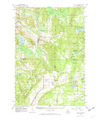
1961 Map of Boyne Falls
USGS Topo · Published 1963About this map
The Boyne River and Jordan River systems carve through this northern Michigan landscape, where high-elevation landmarks like Boyne Mtn and Thunder Mountain provide the backdrop for specialized recreation. In the early 1960s, the area reflects a transition toward tourism, evidenced by Ski Lifts and the Kandahar Landing Strip near Elmira. Local transportation is anchored by the Pennsylvania railroad line, which connects Boyne Falls to the broader regional economy. Significant portions of the terrain are dedicated to the Jordan River State Forest and Chandler State Forest, preserving large tracts of timberland. Genealogists will find a high density of rural burial sites, including the Okrion Cem and St Augustine Cem, alongside isolated municipal landmarks such as the Hudson Lookout Tower and a lonely Schoolhouse north of the Boyne Valley.
Find a feature on this map
86 named features on this map. Tap any name to fly to it.
Don’t see what you’re looking for? This feature index may not catch every label — zoom into the map to look around manually.
Map Details
Editions of this 1961 Boyne Falls Map
2 editions found
Other maps of this area

1949 · Otsego Lake
USGS Topo · 1:62,500

1951 · Otsego Lake
USGS Topo · 1:24,000

1954 · Gaylord
USGS Topo · 1:62,500

1954 · Traverse City
USGS Topo · 1:250,000

1955 · Cheboygan
USGS Topo · 1:250,000

1956 · Alba
USGS Topo · 1:62,500

1956 · Mancelona
USGS Topo · 1:62,500

1957 · Wolverine
USGS Topo · 1:62,500

1958 · Cheboygan
USGS Topo · 1:250,000

1958 · Traverse City
USGS Topo · 1:250,000