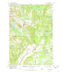
1961 Map of Boyne Falls
USGS Topo · Published 1973About this map
The Pennsylvania railroad and Boyne City Railroad intersect in the village of Boyne Falls, a central transit point in the timber-rich highlands of Northern Michigan. This 1961 field-checked survey reveals a landscape of industrial transitions and recreation, where the Boyne River is utilized for a Powerplant while nearby Boyne Mtn and Thunder Mountain begin to develop as outdoor destinations. The settlement of Elmira anchors the southern portion of the sheet, surrounded by numerous family-named burial grounds including St Thomas Cem and Hallock Cem. Extensive tracts of the Pigeon River State Forest and Jordan River State Forest dominate the terrain, which is punctuated by glacial water bodies like Thumb Lake, Deer Lake, and Losey Lake. Genealogy researchers will find significant value in the distribution of rural landmarks, from the Hudson Lookout Tower to the many gravel pits indicating local mining activity.
Find a feature on this map
78 named features on this map. Tap any name to fly to it.
Don’t see what you’re looking for? This feature index may not catch every label — zoom into the map to look around manually.
Map Details
Editions of this 1961 Boyne Falls Map
2 editions found

Other maps of this area

1949 · Otsego Lake
USGS Topo · 1:62,500

1951 · Otsego Lake
USGS Topo · 1:24,000

1954 · Gaylord
USGS Topo · 1:62,500

1954 · Traverse City
USGS Topo · 1:250,000

1955 · Cheboygan
USGS Topo · 1:250,000

1956 · Alba
USGS Topo · 1:62,500

1956 · Mancelona
USGS Topo · 1:62,500

1957 · Wolverine
USGS Topo · 1:62,500

1958 · Cheboygan
USGS Topo · 1:250,000

1958 · Traverse City
USGS Topo · 1:250,000