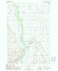
1987 Map of Bozeman Hot Springs
USGS Topo · Published 1988About this map
The confluence of the Gallatin Valley's agricultural heritage and modern recreation is visible here in the late 1980s. Bozeman Hot Springs serves as a prominent landmark near the junction of Four Corners, where the braided channels of the Gallatin River dominate the western half of the map. The landscape is heavily defined by an intricate network of irrigation, with various Ditch and Canal lines drawing water from the river and its tributaries like Hyalite Creek and Dry Creek to support local ranching.
Find a feature on this map
33 named features on this map. Tap any name to fly to it.
Don’t see what you’re looking for? This feature index may not catch every label — zoom into the map to look around manually.
Map Details
Editions of this 1987 Bozeman Hot Springs Map
This is the sole edition of this map. No revisions or reprints were ever made.
Other maps of this area

1888 · Three Forks
USGS Topo · 1:250,000

1894 · Three Forks
USGS Topo · 1:250,000

1895 · Three Forks
USGS Topo · 1:250,000

1947 · Bozeman
USGS Topo · 1:250,000

1948 · Bozeman
USGS Topo · 1:250,000

1949 · Anceney
USGS Topo · 1:62,500

1949 · Manhattan
USGS Topo · 1:62,500

1950 · Belgrade
USGS Topo · 1:62,500

1953 · Bozeman
USGS Topo · 1:62,500

1955 · Bozeman
USGS Topo · 1:250,000