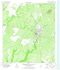
1974 Map of Brackettville
USGS Topo · Published 1977About this map
Brackettville serves as the hub of this Kinney County landscape, situated just north of the extensive grounds of Fort Clark Springs. The map reveals a transition from the town's street grid to the military and frontier legacy of the area, evidenced by the Seminole Indian Scout Cem and Ballantyne Cem. The terrain is defined by the prominent Las Moras Mountain to the northeast and the essential waters of Las Moras Springs that feed into Las Moras Creek.
Find a feature on this map
22 named features on this map. Tap any name to fly to it.
Don’t see what you’re looking for? This feature index may not catch every label — zoom into the map to look around manually.
Map Details
Editions of this 1974 Brackettville Map
This is the sole edition of this map. No revisions or reprints were ever made.
Other maps of this area

1896 · Brackett
USGS Topo · 1:125,000

1897 · Brackett
USGS Topo · 1:125,000

1941 · Standart
USGS Topo · 1:62,500

1941 · Tequesquite Creek
USGS Topo · 1:62,500

1943 · Standart
USGS Topo · 1:62,500

1944 · Tequesquite Creek
USGS Topo · 1:62,500

1944 · Spofford
USGS Topo · 1:62,500

1944 · Brackettville
USGS Topo · 1:62,500

1958 · Del Rio
USGS Topo · 1:250,000

1964 · Del Rio
USGS Topo · 1:250,000