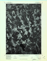
1975 Map of Bradford
USGS Topo · Published 1981About this map
Bradford and its surrounding hamlets are captured in this orthophotograph, providing a rare aerial perspective of the Penobscot County landscape in the mid-1970s. The image reveals a mosaic of cleared agricultural land and dense woodland typical of rural Maine, with the primary settlement at Bradford joined by smaller clusters at Bradford Center and North Bradford. The southern portion of the quadrangle is dominated by the waters of Little Pushaw Pond, which feeds into the winding Pushaw Stream. This transitional era shows the persistence of the traditional road-and-farm network before later twentieth-century development, as local waterways like Dead Stream and West Branch define the natural boundaries of the timber and tilled plots. Genealogists and local historians can use this visual record to locate family homesteads and farmstead footprints near Hudson and along the various brooks that drain this part of the interior.
Find a feature on this map
9 named features on this map. Tap any name to fly to it.
Don’t see what you’re looking for? This feature index may not catch every label — zoom into the map to look around manually.
Map Details
Editions of this 1975 Bradford Map
This is the sole edition of this map. No revisions or reprints were ever made.
Other maps of this area

1902 · Bangor
USGS Topo · 1:62,500

1931 · Stetson
USGS Topo · 1:48,000

1932 · Dover-Foxcroft
USGS Topo · 1:48,000

1933 · Boyd Lake
USGS Topo · 1:62,500

1935 · Dover-Foxcroft
USGS Topo · 1:62,500

1935 · Stetson
USGS Topo · 1:62,500

1942 · Bangor
USGS Topo · 1:62,500

1946 · Bangor
USGS Topo · 1:62,500

1948 · Bangor
USGS Topo · 1:250,000

1951 · Boyd Lake
USGS Topo · 1:50,000