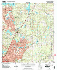
1999 Map of Bradfordville
USGS Topo · Published 2004About this map
The expanding northern edge of Tallahassee is documented here at the close of the century, showing a transition from rural Leon County acreage into residential communities like Killearn Lakes and Killearn Estates. Older family footprints remain visible through landmarks like the Bradford-Eppes Cem and Lester Cem, alongside established local congregations such as Pisgah Ch and Swain Bethel Ch. The landscape is defined by its numerous water bodies, ranging from the large Lake Iamonia in the north to the meticulously placed neighborhood lakes of Killearn Acres, including Lake Saratoga and Lake Sheelin. Public recreation and conservation efforts are prominent, anchored by the Alfred B Maclay Gardens State Park near Lake Hall and the preserved corridor of the Miccosukee Canopy Road Greenway County Park, which protects the region's distinctive tree-lined thoroughfares.
Find a feature on this map
61 named features on this map. Tap any name to fly to it.
Don’t see what you’re looking for? This feature index may not catch every label — zoom into the map to look around manually.
Map Details
Editions of this 1999 Bradfordville Map
This is the sole edition of this map. No revisions or reprints were ever made.
Other maps of this area

1940 · Tallahassee
USGS Topo · 1:62,500

1942 · Tallahassee
USGS Topo · 1:62,500

1943 · Tallahassee
USGS Topo · 1:62,500

1954 · Lloyd
USGS Topo · 1:24,000

1954 · Lafayette
USGS Topo · 1:24,000

1954 · Tallahassee
USGS Topo · 1:250,000

1956 · Calvary
USGS Topo · 1:24,000

1957 · Beachton
USGS Topo · 1:24,000

1957 · Miccosukee NE
USGS Topo · 1:24,000

1959 · Tallahassee
USGS Topo · 1:250,000