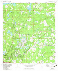
1982 Map of Bradfordville
USGS Topo · Published 1983About this map
Lake Iamonia dominates the northern reaches of this Florida landscape, characterized by its complex shoreline and named arms like Cromartie Arm. The early 1980s represent a significant period of suburban expansion north of Tallahassee, evidenced by the planned layouts of Killearn Estates, Killearn Acres, and Shannon Forest. This residential growth is superimposed over an older rural framework of named ponds and small family-linked landmarks, including the Bradford-Eppes Cem and Lester Cem.
Find a feature on this map
78 named features on this map. Tap any name to fly to it.
Don’t see what you’re looking for? This feature index may not catch every label — zoom into the map to look around manually.
Map Details
Editions of this 1982 Bradfordville Map
This is the sole edition of this map. No revisions or reprints were ever made.
Other maps of this area

1940 · Tallahassee
USGS Topo · 1:62,500

1942 · Tallahassee
USGS Topo · 1:62,500

1943 · Tallahassee
USGS Topo · 1:62,500

1954 · Lloyd
USGS Topo · 1:24,000

1954 · Lafayette
USGS Topo · 1:24,000

1954 · Tallahassee
USGS Topo · 1:250,000

1956 · Calvary
USGS Topo · 1:24,000

1957 · Beachton
USGS Topo · 1:24,000

1957 · Miccosukee NE
USGS Topo · 1:24,000

1959 · Tallahassee
USGS Topo · 1:250,000