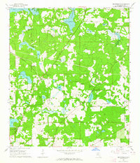
1963 Map of Bradfordville
USGS Topo · Published 1964About this map
The community of Bradfordville serves as the focal point for this rural Leon County landscape in the early 1960s, a region characterized by numerous sinkhole lakes and a deep-rooted religious and social fabric. Small country churches and burial grounds such as New Bethlehem Ch, Spring Hill Ch, and the Lester Cem are scattered across the terrain, reflecting the area's agricultural heritage and family settlements. To the north, the substantial waters of Lake Iamonia and its Cromartie Arm dominate the topography, while the southern reaches feature the manicured grounds of Kill Earn Gardens State Park and Alfred B Maclay State Park. The road network, including Bannerman Road and Roberts Road, connects these disparate settlements and water bodies, illustrating the early transition of this former plantation country into a more accessible residential and recreational landscape near the state capital.
Find a feature on this map
41 named features on this map. Tap any name to fly to it.
Don’t see what you’re looking for? This feature index may not catch every label — zoom into the map to look around manually.
Map Details
Editions of this 1963 Bradfordville Map
This is the sole edition of this map. No revisions or reprints were ever made.
Other maps of this area

1940 · Tallahassee
USGS Topo · 1:62,500

1942 · Tallahassee
USGS Topo · 1:62,500

1943 · Tallahassee
USGS Topo · 1:62,500

1954 · Lloyd
USGS Topo · 1:24,000

1954 · Lafayette
USGS Topo · 1:24,000

1954 · Tallahassee
USGS Topo · 1:250,000

1956 · Calvary
USGS Topo · 1:24,000

1957 · Beachton
USGS Topo · 1:24,000

1957 · Miccosukee NE
USGS Topo · 1:24,000

1959 · Tallahassee
USGS Topo · 1:250,000