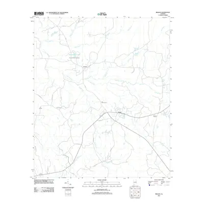
2011 Map of Braggs
USGS Topo · Published 2011About this map
Braggs and Fostoria anchor this rural landscape in Lowndes County, where a network of family cemeteries and winding creeks defines the local geography. The terrain is deeply carved by water, with Dry Cedar Creek and its many tributaries, including Green Branch and Middle Creek, creating a complex drainage pattern throughout the quadrangle. For those studying local lineage, the map identifies several burial grounds such as Sills Cemetery, Oliver Cemetery, and New Bethel Cemetery, which remain key markers of community history. Infrastructure in this era consists primarily of local roads like Casey Rd and Old Braggs Rd, connecting disparate farms and homesteads. Further north, the presence of Quailwood Farms Lakes and the Florence Cabiniss Lake Dam indicates 21st-century water management efforts amidst the older settlement patterns of Alabama's Black Belt region.
Find a feature on this map
34 named features on this map. Tap any name to fly to it.
Don’t see what you’re looking for? This feature index may not catch every label — zoom into the map to look around manually.
Map Details
Editions of this 2011 Braggs Map
This is the sole edition of this map. No revisions or reprints were ever made.
Other maps of this area

1953 · Montgomery
USGS Topo · 1:250,000

1953 · Andalusia
USGS Topo · 1:250,000

1956 · Montgomery
USGS Topo · 1:250,000

1957 · Montgomery
USGS Topo · 1:250,000

1957 · Andalusia
USGS Topo · 1:250,000

1957 · Braggs
USGS Topo · 1:62,500

1971 · Fort Dale
USGS Topo · 1:24,000

1981 · Pine Apple North
USGS Topo · 1:24,000
1981 · Gordonsville
USGS Topo · 1:24,000
1981 · Mount Willing
USGS Topo · 1:24,000