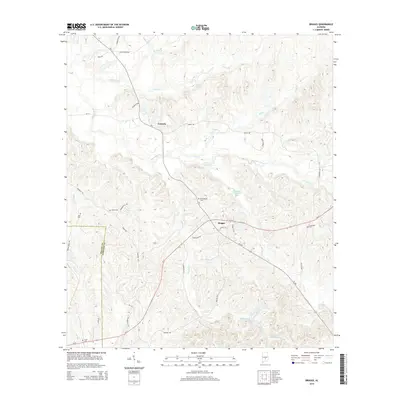
2014 Map of Braggs
USGS Topo · Published 2014About this map
Fostoria and Braggs anchor this interior Alabama landscape where the boundary between Wilcox Co and Lowndes Co meets. The terrain is defined by a dense network of tributaries including Dry Cedar Creek, Sullivan Br, and Middle Cr, which carve through the rural countryside. Local history is etched into the land through numerous small burial grounds, such as Oliver Cem near Farmersville Rd and New Bethel Cem situated north of the Braggs settlement. The Presence of the Container Corporation Lake indicates the modern industrial land use in this timber-rich region, while roads like Strickland Rd and Al-21 trace the established routes between these unincorporated communities. Genealogists will find interest in the proximity of family-named sites like Sills Cem and Crum Cem that persist in the modern topography.
Find a feature on this map
43 named features on this map. Tap any name to fly to it.
Don’t see what you’re looking for? This feature index may not catch every label — zoom into the map to look around manually.
Map Details
Editions of this 2014 Braggs Map
This is the sole edition of this map. No revisions or reprints were ever made.
Other maps of this area

1953 · Montgomery
USGS Topo · 1:250,000

1953 · Andalusia
USGS Topo · 1:250,000

1956 · Montgomery
USGS Topo · 1:250,000

1957 · Montgomery
USGS Topo · 1:250,000

1957 · Andalusia
USGS Topo · 1:250,000

1957 · Braggs
USGS Topo · 1:62,500

1971 · Fort Dale
USGS Topo · 1:24,000

1981 · Pine Apple North
USGS Topo · 1:24,000
1981 · Gordonsville
USGS Topo · 1:24,000
1981 · Mount Willing
USGS Topo · 1:24,000