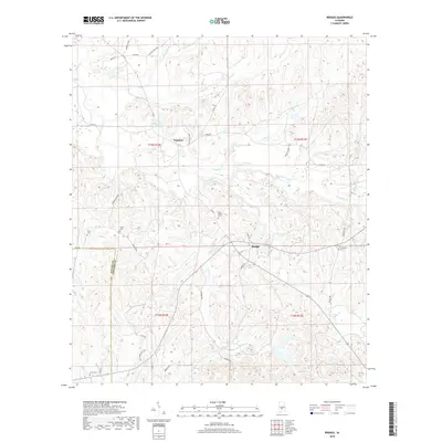
2018 Map of Braggs
USGS Topo · Published 2018About this map
The settlement of Braggs sits along a network of rural roads where the Wilcox Co Lowndes Co boundary line divides the landscape. This 2018 survey reveals a terrain defined by many small creek branches, such as Dry Cedar Cr and Middle Cr, that have shaped the settlement patterns of this corner of Alabama. Local history is preserved through numerous family and community burial sites scattered across the township lines, including New Bethel Cem and Oliver Cem. Near the northern border, Florence Cobiniss Lake and the small community of Fostoria stand out as primary landmarks in an area otherwise dominated by agriculture and forestry. To the south, the presence of Dutch Bend Village along Co Rd 11 indicates newer development patterns in this historically agricultural region.
Find a feature on this map
43 named features on this map. Tap any name to fly to it.
Don’t see what you’re looking for? This feature index may not catch every label — zoom into the map to look around manually.
Map Details
Editions of this 2018 Braggs Map
This is the sole edition of this map. No revisions or reprints were ever made.
Other maps of this area

1953 · Montgomery
USGS Topo · 1:250,000

1953 · Andalusia
USGS Topo · 1:250,000

1956 · Montgomery
USGS Topo · 1:250,000

1957 · Montgomery
USGS Topo · 1:250,000

1957 · Andalusia
USGS Topo · 1:250,000

1957 · Braggs
USGS Topo · 1:62,500

1971 · Fort Dale
USGS Topo · 1:24,000

1981 · Pine Apple North
USGS Topo · 1:24,000
1981 · Gordonsville
USGS Topo · 1:24,000
1981 · Mount Willing
USGS Topo · 1:24,000