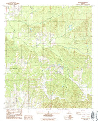
1987 Map of Braggs
USGS Topo · Published 1987About this map
Braggs sits as a central settlement in this late 20th-century landscape, positioned along the shifting drainage divide of the Alabama Black Belt. The topography is defined by a dense network of seasonal and perennial waterways, including Dry Cedar Creek and Middle Creek, which carve through the Lowndes and Wilcox county line. Small, localized settlements such as Fostoria and Sullivan are connected by a web of unimproved roads and trails, reflecting a rural economy tied to the land long after the peak of the region's plantation era. Numerous unnamed Cemeteries are scattered across the quadrangle, serving as critical markers for genealogists tracing family histories in these upland timber and agricultural tracts. The map captures the area just as modern forest management and rural preservation began to shape the current character of the Deep South interior.
Find a feature on this map
14 named features on this map. Tap any name to fly to it.
Don’t see what you’re looking for? This feature index may not catch every label — zoom into the map to look around manually.
Map Details
Editions of this 1987 Braggs Map
This is the sole edition of this map. No revisions or reprints were ever made.
Other maps of this area

1953 · Montgomery
USGS Topo · 1:250,000

1953 · Andalusia
USGS Topo · 1:250,000

1956 · Montgomery
USGS Topo · 1:250,000

1957 · Montgomery
USGS Topo · 1:250,000

1957 · Andalusia
USGS Topo · 1:250,000

1957 · Braggs
USGS Topo · 1:62,500

1971 · Fort Dale
USGS Topo · 1:24,000

1981 · Pine Apple North
USGS Topo · 1:24,000
1981 · Gordonsville
USGS Topo · 1:24,000
1981 · Mount Willing
USGS Topo · 1:24,000