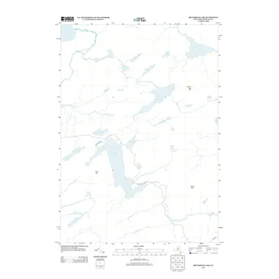
2013 Map of Brandreth Lake
USGS Topo · Published 2013About this map
Brandreth Lake serves as the central hub for this network of Adirondack water bodies, connected by specialized access routes like Brandreth Park Way and Jackworks Way. The landscape is defined by a series of interconnected ponds and brooks, including the sprawling N Pond Flowgrounds and the tucked-away Little Salmon Lake. Elevations are anchored by prominent peaks such as Buck Mtn and Pilgrim Mtn, which overlook the complex hydrology of the region. The map captures the distinct character of managed wilderness, where natural features like Touey Falls and Salmon Lake Outlet are accessible via a limited network of private or restricted roads. In the northwest corner, the expansive Lake Lila sits at the head of Shingle Shanty Brook, illustrating the drainage patterns that have shaped this portion of Hamilton County.
Find a feature on this map
31 named features on this map. Tap any name to fly to it.
Don’t see what you’re looking for? This feature index may not catch every label — zoom into the map to look around manually.
Map Details
Editions of this 2013 Brandreth Lake Map
This is the sole edition of this map. No revisions or reprints were ever made.
Other maps of this area

1903 · Big Moose
USGS Topo · 1:62,500

1903 · Raquette Lake
USGS Topo · 1:62,500

1907 · Tupper Lake
USGS Topo · 1:62,500

1919 · Cranberry Lake
USGS Topo · 1:62,500

1921 · Cranberry Lake
USGS Topo · 1:62,500

1931 · Cranberry Lake
USGS Topo · 1:62,500

1948 · Ogdensburg
USGS Topo · 1:250,000

1950 · Utica
USGS Topo · 1:250,000

1951 · Ogdensburg
USGS Topo · 1:250,000

1953 · Ogdensburg
USGS Topo · 1:250,000