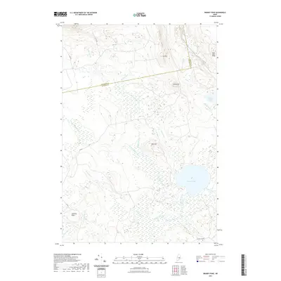
2021 Map of Brandy Pond
USGS Topo · Published 2021About this map
Brandy Pond and its surrounding wetlands form the centerpiece of this interior Maine landscape, where the boundary between Penobscot and Hancock counties cuts through a network of remote brooks and ridges. The terrain is defined by low-lying drainages like Buffalo Stream and Pug Hole Brook which weave between prominent elevations such as Lord Mtn and Buffalo Hill. This survey highlights the region's hydrography, showing how Brandy Stream and Indian Brook feed into the primary basin. A series of timber-management or fire roads, including 24-00-0 and Brandy Pond Rd, provide the only terrestrial access through these woods. For the researcher, the map captures the late-twentieth-century drainage patterns and topographical relief of a largely unpopulated wilderness, illustrating the complex wetland ecosystems that characterize the Maine interior near Upper Oxhead Pond.
Find a feature on this map
27 named features on this map. Tap any name to fly to it.
Don’t see what you’re looking for? This feature index may not catch every label — zoom into the map to look around manually.
Map Details
Editions of this 2021 Brandy Pond Map
This is the sole edition of this map. No revisions or reprints were ever made.
Other maps of this area

1929 · Great Pond
USGS Topo · 1:48,000

1929 · Lead Mountain
USGS Topo · 1:48,000

1931 · Saponac
USGS Topo · 1:48,000

1932 · Nicatous Lake
USGS Topo · 1:48,000

1932 · Lead Mountain
USGS Topo · 1:62,500

1932 · Great Pond
USGS Topo · 1:62,500

1934 · Saponac
USGS Topo · 1:62,500

1934 · Nicatous Lake
USGS Topo · 1:62,500

1948 · Bangor
USGS Topo · 1:250,000

1954 · Millinocket
USGS Topo · 1:250,000