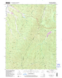
1999 Map of Brandywine
USGS Topo · Published 2001About this map
The South Fork Potomac River flows through the western edge of this landscape, anchoring the community of Brandywine. Located at the intersection of several mountain drainages, this area shows a transition from the river valley settlements to the protected heights of the George Washington National Forest. Genealogists and local researchers will find several notable landmarks, including the Martin Luther Ch and Cedar Grove Ch, along with the Pine Hill Cem. The topography is dominated by massive ridges like Heavener Mountain and Richland Mountain, which define the many hollows and runs that feed the Potomac. High points such as Flagpole Knob and the High Knob Lookout Tower offer vantage points over the state line shared by West Virginia and Virginia. Public land management is evident through features like Brandywine Lake and the Brandywine Recreation Area, indicating the balance of community life and wilderness preservation at the close of the 20th century.
Find a feature on this map
60 named features on this map. Tap any name to fly to it.
Don’t see what you’re looking for? This feature index may not catch every label — zoom into the map to look around manually.
Map Details
Editions of this 1999 Brandywine Map
This is the sole edition of this map. No revisions or reprints were ever made.
Other maps of this area

1892 · Franklin
USGS Topo · 1:125,000

1894 · Staunton
USGS Topo · 1:125,000

1896 · Franklin
USGS Topo · 1:125,000

1922 · Fort Seybert
USGS Topo · 1:48,000

1922 · Circleville
USGS Topo · 1:62,500

1924 · Circleville
USGS Topo · 1:48,000

1924 · Mc Dowell
USGS Topo · 1:62,500

1924 · Fort Seybert
USGS Topo · 1:62,500

1944 · Parnassus
USGS Topo · 1:62,500

1944 · Mc Dowell
USGS Topo · 1:62,500