
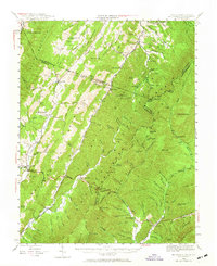
1944 Map of Mc Dowell
USGS Topo · Published 1960About this map
Mc Dowell serves as a central hub in this 1944 topographic survey, situated at the confluence of Bullpasture River and Crab Run. The landscape is dominated by the massive parallel ridges of Bullpasture Mountain and Shenandoah Mountain, creating a terrain of deep hollows and narrow valleys. This settlement pattern reflects the traditional Appalachian reliance on water gaps and river bottoms for agriculture and passage, as seen in the cluster of landmarks like Siron's Mill and McKendree Ch.
Find a feature on this map
72 named features on this map. Tap any name to fly to it.
Don’t see what you’re looking for? This feature index may not catch every label — zoom into the map to look around manually.
Map Details
Editions of this 1944 Mc Dowell Map
2 editions found
Other maps of this area

1889 · Beverly
USGS Topo · 1:125,000

1892 · Beverly
USGS Topo · 1:125,000

1892 · Franklin
USGS Topo · 1:125,000

1894 · Staunton
USGS Topo · 1:125,000

1896 · Franklin
USGS Topo · 1:125,000

1901 · Monterey
USGS Topo · 1:125,000

1922 · Fort Seybert
USGS Topo · 1:48,000

1922 · Spruce Knob
USGS Topo · 1:48,000

1922 · Circleville
USGS Topo · 1:62,500

1924 · Circleville
USGS Topo · 1:48,000