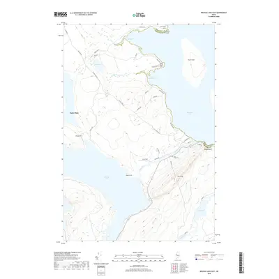
2018 Map of Brassua Lake East
USGS Topo · Published 2018About this map
Moosehead Lake dominates the eastern edge of this landscape, its expansive waters meeting the shoreline at Tomhegan Point and Baker Brook Point. The village of Rockwood sits at the eastern gateway, where the Moose River flows into the larger lake. This waterway serves as a vital corridor between the major lakes, connecting to Little Brassua Lake in the south and passing near Avery Field. The terrain is defined by prominent elevations such as Blue Ridge and Poplar Hill, which rise above the surrounding wetlands and smaller water bodies like Baker Pond.
Find a feature on this map
45 named features on this map. Tap any name to fly to it.
Don’t see what you’re looking for? This feature index may not catch every label — zoom into the map to look around manually.
Map Details
Editions of this 2018 Brassua Lake East Map
This is the sole edition of this map. No revisions or reprints were ever made.
Other maps of this area

1920 · Moosehead Lake
USGS Topo · 1:62,500

1921 · Brassua Lake
USGS Topo · 1:62,500

1922 · Moosehead Lake
USGS Topo · 1:62,500

1923 · Brassua Lake
USGS Topo · 1:62,500

1930 · Moosehead Lake
USGS Topo · 1:62,500

1944 · Brassua Lake
USGS Topo · 1:62,500

1944 · Moosehead Lake
USGS Topo · 1:62,500

1954 · Seboomook Lake
USGS Topo · 1:62,500

1954 · North East Carry
USGS Topo · 1:62,500

1954 · Millinocket
USGS Topo · 1:250,000
Featured Places
- Rockwood Strip T2 R1 NBKP, ME
- Kineo Township, ME
- Tomhegan Township, ME
- Sandwich Academy Grant Township, ME
- Rockwood Strip T1 R1 NBKP, ME