
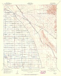
1940 Map of Brawley
USGS Topo · Published 1955About this map
The New River carves a sinuous path through this 1940 Imperial Valley landscape, highlighting a complex irrigation and transport network developed shortly before the mid-century. A grid of irrigation canals, including the Main Canal, Thistle Canal, and Tokay Canal, supports the agricultural expansion surrounding the major hubs of Brawley, Imperial, and El Centro. The map illustrates the transition from the desert basin, marked by the Sea Level contour, to a highly managed agricultural plain.
Find a feature on this map
39 named features on this map. Tap any name to fly to it.
Don’t see what you’re looking for? This feature index may not catch every label — zoom into the map to look around manually.
Map Details
Editions of this 1940 Brawley Map
This is the sole edition of this map. No revisions or reprints were ever made.
Other maps of this area

1907 · Holtville
USGS Topo · 1:125,000

1915 · El Centro
USGS Topo · 1:125,000

1940 · Kane Spring
USGS Topo · 1:62,500
1940 · Iris
USGS Topo · 1:62,500
1940 · Heber
USGS Topo · 1:62,500

1940 · Plaster City
USGS Topo · 1:62,500

1940 · Alamorio
USGS Topo · 1:62,500

1940 · Coyote Wells
USGS Topo · 1:62,500
1940 · Calexico
USGS Topo · 1:62,500

1942 · El Centro
USGS Topo · 1:250,000