
1943 Map of Brawley
USGS Topo · Published 1945About this map
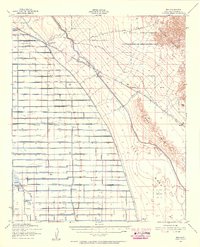
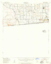
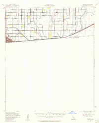
Brawley, Imperial, and El Centro anchor this highly engineered agricultural landscape in the Imperial Valley during the mid-1940s. The map illustrates a dense, artificial vascular system of irrigation and drainage essential for desert cultivation, featuring the Westside Main Canal and a grid of named channels like Thistle Canal and Dogwood Canal. The New River meanders north toward the Salton Sea, contrasting with the rigid geometry of the surrounding fields and the Southern Pacific rail lines. Rural life is marked by a network of local schools, including Lantana Sch. and Elm Sch, which served the scattered farmsteads of the era. The infrastructure of the agricultural economy is further evidenced by rail stops like Grape Siding and the presence of the Holton Interurban line, reflecting the logistical complexity of transporting valley produce to distant markets.
Find a feature on this map
43 named features on this map. Tap any name to fly to it.
Don’t see what you’re looking for? This feature index may not catch every label — zoom into the map to look around manually.
Map Details
Editions of this 1943 Brawley Map
This is the sole edition of this map. No revisions or reprints were ever made.
Other maps of this area

1907 · Holtville
USGS Topo · 1:125,000

1915 · El Centro
USGS Topo · 1:125,000

1940 · Brawley
USGS Topo · 1:62,500

1940 · Kane Spring
USGS Topo · 1:62,500
1940 · Iris
USGS Topo · 1:62,500
1940 · Heber
USGS Topo · 1:62,500

1940 · Plaster City
USGS Topo · 1:62,500

1940 · Alamorio
USGS Topo · 1:62,500

1940 · Coyote Wells
USGS Topo · 1:62,500
1940 · Calexico
USGS Topo · 1:62,500