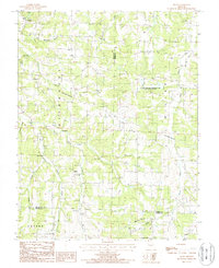
1987 Map of Brays
USGS Topo · Published 1988About this map
The settlement of Brays sits at the northwestern edge of this landscape where the Elm Springs Branch flows through the Ozark hills. The area is defined by a dense network of watercourses, including the Maries River, the Little Maries River, and Little Tavern Creek, which carve deep valleys through the terrain. A notable feature of the local geography is the numerous designated Sand Areas along the riverbanks, suggesting a dynamic fluvial environment before the modern era of heavy management.
Find a feature on this map
21 named features on this map. Tap any name to fly to it.
Don’t see what you’re looking for? This feature index may not catch every label — zoom into the map to look around manually.
Map Details
Editions of this 1987 Brays Map
This is the sole edition of this map. No revisions or reprints were ever made.
Other maps of this area

1888 · Tuscumbia
USGS Topo · 1:125,000

1894 · Tuscumbia
USGS Topo · 1:125,000

1933 · Iberia
USGS Topo · 1:62,500

1936 · Waynesville
USGS Topo · 1:48,000

1937 · Iberia
USGS Topo · 1:62,500

1942 · Waynesville
USGS Topo · 1:62,500

1943 · Richland
USGS Topo · 1:62,500

1944 · Waynesville
USGS Topo · 1:62,500

1947 · Jefferson City
USGS Topo · 1:250,000

1948 · Tavern
USGS Topo · 1:62,500