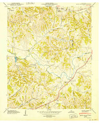
1949 Map of Brick Church
USGS Topo · Published 1949About this map
Richland Creek winds through a landscape of deeply etched hollows and ridges along the Giles Marshall county line in this mid-century survey. The settlement of Brick Church serves as a central hub for the surrounding rural community, supported by the Brick Church School and proximity to family burial grounds like Burton Cem. The terrain is characterized by a dense network of watercourses and naming traditions, from the waters of Blue Creek and Robertson Fork Cr to the numerous family-named landmarks including Kincaid Cem and Dabney Cem.
Find a feature on this map
43 named features on this map. Tap any name to fly to it.
Don’t see what you’re looking for? This feature index may not catch every label — zoom into the map to look around manually.
Map Details
Editions of this 1949 Brick Church Map
3 editions found
Other maps of this area

1936 · Milky Way
USGS Topo · 1:24,000

1936 · Cornersville
USGS Topo · 1:24,000

1936 · Lewisburg
USGS Topo · 1:24,000

1936 · Brick Church
USGS Topo · 1:24,000

1936 · Campbells Station
USGS Topo · 1:24,000

1936 · Pulaski
USGS Topo · 1:24,000

1936 · Tarpley
USGS Topo · 1:24,000

1936 · Frankewing
USGS Topo · 1:24,000

1936 · Lynnville
USGS Topo · 1:24,000

1946 · Brick Church
USGS Topo · 1:24,000