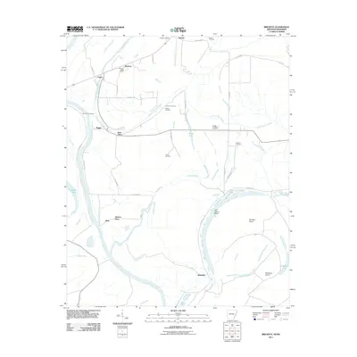
2011 Map of Brickeys
USGS Topo · Published 2011About this map
Brickeys and its local Brickeys Post Office anchor this section of Lee County, Arkansas, where the alluvial landscape is defined by the winding course of the Saint Francis River and a complex network of bayous. The map captures a rural settlement pattern where family and community heritage is preserved in numerous burial sites like Ward Farm Cemetery, Gassett Cemetery, and Greater Jerusalem Cemetery.
Find a feature on this map
45 named features on this map. Tap any name to fly to it.
Don’t see what you’re looking for? This feature index may not catch every label — zoom into the map to look around manually.
Map Details
Editions of this 2011 Brickeys Map
This is the sole edition of this map. No revisions or reprints were ever made.
Other maps of this area

1931 · Horseshoe Lake
USGS Topo · 1:62,500

1939 · Clayton
USGS Topo · 1:62,500

1939 · Horseshoe Lake
USGS Topo · 1:62,500

1939 · Park Place
USGS Topo · 1:62,500

1939 · Latour
USGS Topo · 1:62,500

1948 · Helena
USGS Topo · 1:250,000

1950 · Helena
USGS Topo · 1:250,000

1954 · Horseshoe Lake
USGS Topo · 1:62,500
1955 · Clayton
USGS Topo · 1:62,500

1955 · Park Place
USGS Topo · 1:62,500