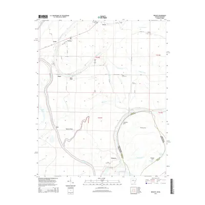
2014 Map of Brickeys
USGS Topo · Published 2014About this map
Saint Francis River and its meandering tributaries define this landscape along the Arkansas-Mississippi state line, where Lee and Tunica counties meet. The map reveals a rural delta environment heavily influenced by water, featuring complex drainage systems like S Alligator Bayou, North Alligator Bayou, and the swampy Whiskey Chute. Small settlements such as Brickeys, Raggio, and Whitehall are connected by a network of local roads, while Us-79 provides regional access through the northern section. Numerous family and community burial grounds, including Ward Farm Cem and Shepherd Grove Cem, are scattered across the terrain, offering significant value for genealogical research. The river's historical shifts are visible at Old Walnut Bend and Bordeaux Island Old Bordeaux Chute, reflecting the dynamic nature of the Mississippi River floodplain during this era.
Find a feature on this map
62 named features on this map. Tap any name to fly to it.
Don’t see what you’re looking for? This feature index may not catch every label — zoom into the map to look around manually.
Map Details
Editions of this 2014 Brickeys Map
This is the sole edition of this map. No revisions or reprints were ever made.
Other maps of this area

1931 · Horseshoe Lake
USGS Topo · 1:62,500

1939 · Clayton
USGS Topo · 1:62,500

1939 · Horseshoe Lake
USGS Topo · 1:62,500

1939 · Park Place
USGS Topo · 1:62,500

1939 · Latour
USGS Topo · 1:62,500

1948 · Helena
USGS Topo · 1:250,000

1950 · Helena
USGS Topo · 1:250,000

1954 · Horseshoe Lake
USGS Topo · 1:62,500
1955 · Clayton
USGS Topo · 1:62,500

1955 · Park Place
USGS Topo · 1:62,500