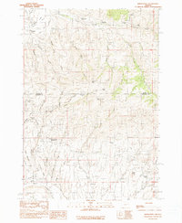
1990 Map of Bridgeport
USGS Topo · Published 1990About this map
Bridgeport and the surrounding high desert canyonlands of the Burnt River basin reveal a landscape deeply shaped by 19th-century resource extraction. This 1990 provisional study identifies several significant historic locations, including the gold-mining remnants of Malheur City and Clarksville, alongside the notably identified China Town. The intricate network of hydraulic engineering is evident through labels for the Eldorado Ditch, Auburn Ditch, and Elliot Ditch, which once carried water across this arid terrain to fuel placer mining operations. From the high point of Bill Neighbor Peak to the basin at Kentucky Flat, the map documents the Baker and Malheur county line as it traverses a territory of steep gulches and prominent landmarks like Amelia Butte. The presence of the Iron Door Mine and various prospects underscores the region's enduring identity as a frontier of mineral discovery.
Find a feature on this map
51 named features on this map. Tap any name to fly to it.
Don’t see what you’re looking for? This feature index may not catch every label — zoom into the map to look around manually.
Map Details
Editions of this 1990 Bridgeport Map
This is the sole edition of this map. No revisions or reprints were ever made.
Other maps of this area

1901 · Baker City
USGS Topo · 1:125,000

1955 · Baker
USGS Topo · 1:250,000

1959 · Baker
USGS Topo · 1:250,000

1964 · Bridgeport
USGS Topo · 1:62,500

1964 · Ironside
USGS Topo · 1:62,500

1967 · French Gulch
USGS Topo · 1:24,000

1967 · Dooley Mtn
USGS Topo · 1:24,000

1967 · Lost Basin
USGS Topo · 1:24,000

1980 · Brogan
USGS Topo · 1:100,000

1981 · Baker
USGS Topo · 1:100,000