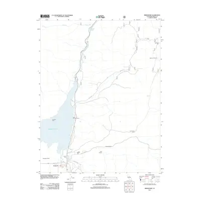
2012 Map of Bridgeport
USGS Topo · Published 2012About this map
Bridgeport serves as the focal point of this Eastern Sierra landscape, situated at the southern end of the vast Bridgeport Valley. The settlement’s infrastructure is clearly defined, featuring Bryant Field and a network of named local streets such as Emigrant St and Milk-Ranch Rd. The dominant hydrological feature is the Bridgeport Reservoir, which captures the flow of the E Walker River as it moves north through Rock Springs Canyon. To the east, the terrain rises sharply toward Masonic Mountain and New York Hill, areas historically shaped by mining and grazing. The map meticulously records numerous water sources essential for high-altitude ranching and travel, including Lakeview Spring, McMillan Spring, and Logan Spring. This 2012 survey illustrates the modern layout of this historic county seat, balancing the town’s development with the rugged geographic formations of Aurora Canyon and Locomotive Point.
Find a feature on this map
25 named features on this map. Tap any name to fly to it.
Don’t see what you’re looking for? This feature index may not catch every label — zoom into the map to look around manually.
Map Details
Editions of this 2012 Bridgeport Map
This is the sole edition of this map. No revisions or reprints were ever made.
Other maps of this area

1909 · Bridgeport
USGS Topo · 1:125,000

1911 · Bridgeport
USGS Topo · 1:125,000

1920 · Bridgeport
USGS Topo · 1:125,000

1948 · Walker Lake
USGS Topo · 1:250,000

1956 · Fales Hot Springs
USGS Topo · 1:62,500

1956 · Matterhorn Peak
USGS Topo · 1:62,500

1957 · Walker Lake
USGS Topo · 1:250,000

1958 · Bodie
USGS Topo · 1:62,500
1958 · Bridgeport
USGS Topo · 1:62,500

1962 · Walker Lake
USGS Topo · 1:250,000