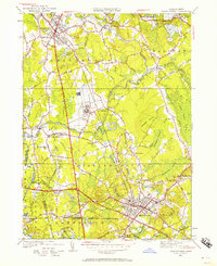
1949 Map of Bridgewater
USGS Topo · Published 1957About this map
The Taunton River and Nemasket River systems define this landscape in Plymouth County during the late 1940s, a period when the agricultural traditions of southeastern Massachusetts met mid-century institutional expansion. At the heart of the map lies the massive complex of the State Farm, located near South Bridgewater, which dominates the central plains. To the south, the village of Middleboro serves as a dense residential and commercial hub, anchored by the New York New Haven and Hartford RR and numerous civic markers such as the Lakeville State Sanitorium and St Marys Cem. The map reveals a transition from traditional town centers like Bridgewater and The Green to more distributed rural settlements. Local life is documented through scattered landmarks like the Plymouth Street Sch and the extensive Fair Grounds, while the presence of Fish Bog and Washburn Bog reflects the region’s enduring cranberry industry and wetland management.
Find a feature on this map
56 named features on this map. Tap any name to fly to it.
Don’t see what you’re looking for? This feature index may not catch every label — zoom into the map to look around manually.
Map Details
Editions of this 1949 Bridgewater Map
This is the sole edition of this map. No revisions or reprints were ever made.
Other maps of this area

1885 · Abington
USGS Topo · 1:62,500

1885 · Middleboro
USGS Topo · 1:62,500

1885 · Taunton
USGS Topo · 1:62,500

1886 · Dedham
USGS Topo · 1:62,500

1888 · Taunton
USGS Topo · 1:62,500

1888 · Middleboro
USGS Topo · 1:62,500

1888 · Abington
USGS Topo · 1:62,500

1893 · Abington
USGS Topo · 1:62,500

1893 · Taunton
USGS Topo · 1:62,500

1893 · Middleboro
USGS Topo · 1:62,500