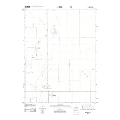
2011 Map of Briggsdale
USGS Topo · Published 2011About this map
Briggsdale sits as the primary settlement in this corner of Weld County, characterized by a grid of streets and a community hub near Crow Valley Park. The landscape is defined by its agricultural and pastoral utility, where water management is paramount. Numerous windmills, including Arrowhead Windmill and Lee Windmill, are scattered across the high plains, marking the reliance on groundwater for livestock and homesteads. The drainage of Crow Creek and its tributaries, such as Little Crow Creek, weave through the terrain, occasionally interrupted by man-made structures like Heart Dam and its associated Heart Reservoir. This 2011 survey captures the area's mix of public lands and private ranching, anchored by local landmarks such as the Briggsdale Cemetery and the Crow Valley Recreation Area, which provide a window into the social and historical geography of this prairie community.
Find a feature on this map
29 named features on this map. Tap any name to fly to it.
Don’t see what you’re looking for? This feature index may not catch every label — zoom into the map to look around manually.
Map Details
Editions of this 2011 Briggsdale Map
This is the sole edition of this map. No revisions or reprints were ever made.
Other maps of this area

1954 · Greeley
USGS Topo · 1:250,000

1957 · Greeley
USGS Topo · 1:250,000

1958 · Greeley
USGS Topo · 1:250,000

1961 · Greeley
USGS Topo · 1:250,000

1964 · Greeley
USGS Topo · 1:250,000

1965 · Greeley
USGS Topo · 1:250,000

1972 · Dutch Girl Lake
USGS Topo · 1:24,000

1972 · Briggsdale
USGS Topo · 1:24,000

1972 · Keota NW
USGS Topo · 1:24,000
1972 · Reno Reservoir
USGS Topo · 1:24,000