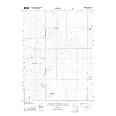
2013 Map of Briggsdale
USGS Topo · Published 2013About this map
Briggsdale serves as the focal point of this northeastern Colorado landscape, situated along the southern edge of the Pawnee National Grassland. The settlement pattern is defined by a rigid grid of county roads, including CO Road 77 and State Hwy 14, which cut across the high plains. Water management is a central theme of the terrain, visible through the presence of the Heart Reservoir and Murphy Reservoir, alongside numerous named windmills such as the Arrowhead Windmill and Seven Cross Windmill. These features indicate the region's reliance on groundwater and captured runoff in an arid environment. Local history and community spaces are preserved at the Briggsdale Cem, Crow Valley Park, and the Crow Valley Recreation Area, which offer a contrast to the surrounding agricultural and open range lands. The drainage of Crow Creek and its tributaries, like Howard Creek and Little Crow Creek, provide the primary topographical relief across the township.
Find a feature on this map
42 named features on this map. Tap any name to fly to it.
Don’t see what you’re looking for? This feature index may not catch every label — zoom into the map to look around manually.
Map Details
Editions of this 2013 Briggsdale Map
This is the sole edition of this map. No revisions or reprints were ever made.
Other maps of this area

1954 · Greeley
USGS Topo · 1:250,000

1957 · Greeley
USGS Topo · 1:250,000

1958 · Greeley
USGS Topo · 1:250,000

1961 · Greeley
USGS Topo · 1:250,000

1964 · Greeley
USGS Topo · 1:250,000

1965 · Greeley
USGS Topo · 1:250,000

1972 · Dutch Girl Lake
USGS Topo · 1:24,000

1972 · Briggsdale
USGS Topo · 1:24,000

1972 · Keota NW
USGS Topo · 1:24,000
1972 · Reno Reservoir
USGS Topo · 1:24,000