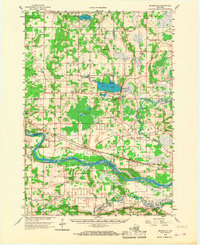
1958 Map of Briggsville
USGS Topo · Published 1968About this map
Mason Lake and its distinctive inlets, Burns Cove and Morris Cove, serve as a central geographic anchor in this 1950s era survey. The village of Briggsville sits at the lake's eastern edge, where the landscape transitions into the wetlands surrounding Neenah Creek. Further south, the broad channel of the Wisconsin River dominates the terrain, featuring the large Pine Island and a sophisticated levee system protecting the low-lying farmlands of Lewiston.
Find a feature on this map
66 named features on this map. Tap any name to fly to it.
Don’t see what you’re looking for? This feature index may not catch every label — zoom into the map to look around manually.
Map Details
Editions of this 1958 Briggsville Map
3 editions found
Other maps of this area

1895 · Baraboo
USGS Topo · 1:62,500

1901 · Denzer
USGS Topo · 1:62,500

1901 · Poynette
USGS Topo · 1:62,500

1901 · The Dells
USGS Topo · 1:62,500

1902 · Portage
USGS Topo · 1:62,500

1902 · Briggsville
USGS Topo · 1:62,500

1908 · Baraboo
USGS Topo · 1:62,500

1957 · Wisconsin Dells
USGS Topo · 1:62,500

1957 · Madison
USGS Topo · 1:250,000

1958 · Briggsville
USGS Topo · 1:62,500