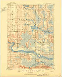
1902 Map of Briggsville
USGS Topo · Published 1950About this map
Mason Lake and its surrounding wetlands serve as a focal point for this early 20th-century survey of the Wisconsin interior. The village of Briggsville sits at the lake's eastern edge, where Neenah Creek continues its winding course toward the southeast. The landscape is defined by its complex hydrology, with the wide, island-studded Wisconsin River cutting a massive curve through the lower portion of the sheet. Further south, the Baraboo River meanders into the region through a broad floodplain.
Find a feature on this map
28 named features on this map. Tap any name to fly to it.
Don’t see what you’re looking for? This feature index may not catch every label — zoom into the map to look around manually.
Map Details
Editions of this 1902 Briggsville Map
4 editions found
Other maps of this area

1895 · Baraboo
USGS Topo · 1:62,500

1901 · Denzer
USGS Topo · 1:62,500

1901 · Poynette
USGS Topo · 1:62,500

1901 · The Dells
USGS Topo · 1:62,500

1902 · Portage
USGS Topo · 1:62,500

1902 · Briggsville
USGS Topo · 1:62,500

1908 · Baraboo
USGS Topo · 1:62,500

1957 · Wisconsin Dells
USGS Topo · 1:62,500

1957 · Madison
USGS Topo · 1:250,000

1958 · Briggsville
USGS Topo · 1:62,500